This is one of many computer models that came in overnight with a shift to a colder, coastal storm for Tuesday. This is only a 50 to 100 mile push east of the storm track, but could be enough to change the whole playing field.
Click here to see the break down of how some of the models looked yesterday. I will be posting my updates on Examiner.com. It is important to know that models do often bounce a little on a storm track days before the event. What is more important is to see if this trend holds.
Friday, January 30, 2009
Could February Bring The Big Storm We Have Been Waiting For?
Wednesday, January 28, 2009
Icy Morning

This winter storm has done it's thing. A little less snow, but it doesn't matter since the freezing rain would have compacted it down. Ice this morning was very bad. Rain continued to fall with temperatures in the 20s. For more cameras, my morning report and snow report for Maryland, click here for Examiner.com
Check out the interactive radar on abc2news.com
Tuesday, January 27, 2009
Winter Storm Warnings and Wniter Weather Advisories
 Does it matter which one at this point? I often wonder if the public cares. "Just tell me how much", is what I hear. This map was my original forecast.
Considering the morning band of snow that moved south, heavier snow may bust that forecast around the bay. Southern Maryland and Ocean City could pick up 1-2 inches this morning alone.
The main storm will build in this afternoon and tonight. It looks colder, and that will delay the change to sleet and rain....but it will happen. That change over will occur from south to north late night and Wednesday morning.
I will update all day on Examiner.com
Thursday, January 22, 2009
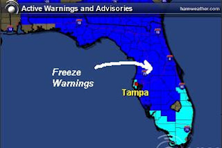
Freeze Warning in Florida
The arctic air has made it all the way down to Florida this week (late January). This morning (Thursday Jan 22) the coldest part of this air mass was passing through. I have a friend working for the Superbowl preparation in Tampa, and their whole crew is chilly! The morning temperatures down into the 30s will threaten the citrus crop all the way down to the southern part of the state.
Freeze Warnings in dark blue
Frost Advisories in light blue
I am posting here, since my latest story on Examiner.com has generated a lot of interest. If you want to read about NASA's report on Oceans Cooling, click here. The link to the original NASA story is in that post.
Monday, January 19, 2009
Inauguration Snow Possible
As I write this, snow showers have already dropped a coating on Kent Island, and the radar is covering central Maryland with snow. My morning post can be found on by clicking on Examiner.com here. I have been watching the models trending a little closer with Tuesday's coastal storm. I have little confidence in most models these days since there has been a strong bias all winter. The bias means that the trend has had these storms verify farther north and west than predicted. If that holds, then Tuesday may end up surprising a lot of people in Washington, DC.
For more on Inauguration Weather, check out my series by clicking below:
Part 1- What is Normal Weather for January Presidential Inaugurations
Part 2- Extreme Weather for Presidential Inaugurations
Thursday, January 8, 2009
State Trooper Flips Over on Icy Road

A quick snow shower that melted, and then refroze led to icy roads in Anne Arundel County this morning. Click here for my full story on Examiner.com
There will be snow showers today, but some accumulating snow on Saturday. I will post more on that this afternoon on Examiner.com
Tuesday, January 6, 2009
Winter Weather Advisory Jan 6 and 7

I am still doing my main posting on Examiner.com... click here for my latest post. However, while you are here there is a lot of weather information on my main web site. Click on the TV Graphics Tab or Radars Tab above. There are also County breakdowns with local weather stations and cams.


