View this full web site Click: JustinWeatherTalk.com. New Blog located at Examiner.com. Local weather and interactive radar at abc2news.com.


My Examiner Home Page- Click this image to view.


Showing posts with label snowfall records. Show all posts

Monday, January 7, 2008

Snow Anniversary, Near Record Heat

If someone tells you that it does not snow much anymore- please correct them. As we stand today for the season in snowfall:

  • 4.8" of Snow
  • Normal: 3.2"
  • 1.6" above normal
Today marks 12 years since the famous storm of 1996. A storm that justified all of the shopping beforehand. It was tagged the "Blizzard of '96", and lasted a few days. Here you can see the daily snowfall records still on the books. Today's record of 15.8" is the second highest 1 day total for Baltimore in January. The snow lasted 3 days, with a total of 26.6"- with over 3 feet in places like Carroll County. Snow drifts were reported over 6 feet in spots. Ironically, the following week, temperatures hit the mid 60s
This brings up the important point of our personal memory with snowy winters. I can't make the point any better than an email I got last week: This snow in 1996 was our #2 storm on record, it melted a week later. Temperatures hit the low 60s on January 18th. Other winters have had less snow that stayed on the ground for a month or more. Sometimes snowfall itself does not stay in our memories, but the duration of snow pack.

As for the current heat... check the Headlines graphic on the right column. I am forecasting 64F, which is still warm, but not the record. Our heat records date back to the period of warming in the early part of the century. Check out these records for the next few days:
  • 7th: 74F in 1907
  • 8th 69F in 1930
  • 9th 75F in 1937

Wednesday, January 2, 2008

Coldest Air ThisSeason/Snowfall Records

My Snowfall Records series continues below... Currently, we are about to experience the coldest air we've had in 10 months. March 7th, '07 was the last time we failed to reach 30F at BWI. Tomorrow will likely stay that cold as well, while overnight lows drop into the teens- even downtown. For contrast- our record high on this date was 71F, way back in 1876. Yes it was warm in January two centuries ago. As for flurries, not the best upper level support with this trough- as we look at the 500mb level for a strong vort max. It will pass well to our south, but the unstable cold air will help clouds develop... only marginal support for flurries or a stray snow shower. Western MD and the ski areas of WV and PA will get a few beneficial inches. The back edge of this trough will swing through tomorrow morning with a small chance of another flurry.

Snowfall Records: 1990s

This is the decade where things get interesting. If you have not seen the rest of the series, continue to scroll down or search for previous posts over the past week. The 1990s shows a range of seasonal snows from the #1 Record ending in 1996 with 62.5" to the 3rd least snow two years later in 1998 with 3.2". We can attribute a strong El Nino to the record snow, and return to La Nina during the low snow years of '91-'92 & '97-'98. The decade itself averaged about 3 inches below the long term average, yet near the 30 year average.
While I love to point out unique stats such as Dec. 5th snowfall or warm Halloweens in Baltimore,
These decades are arbitrary and just a function of our calendar. If we take another arbitrary 10 year span- see the result below. This should prove the point of my whole series... It does not snow less that it did in the past. Climate itself is not consistent. It fluctuates! While we may look at a sample of a few years, or decades, over the course of time we settle of the average. Here you see that this 10 year span brought the extreme of top 2 snow winters and bottom #3 and #4. The average out paces the long term average. If this was all you looked at, you would assume that it actually snows more now than the past. Again- all how you break down the stats. Please- pass on the message, and don't lose hope in this season. "Faith in the Flakes" - JBerk

Saturday, December 29, 2007

Snowfall Records- 1980s

As we look at the 1980s snowfall in Baltimore, the decade is on target with the past 30 year average. But a few outliers are clearly seen. This was a clear El Nino/La Nina decade.


First, '80-'81 and '88-'89 both had less than 10 inches of snow. A La Nina occurred in '88-'89. Yet the '82-'83' season and '86-'87 both had about 35" of snow. These two big seasons were during El Nino. The '82-83' was a very strong El Nino that led to billions of dollars in damage in CA, and instigated the current research and government funding for satellites and buoys. The '86-'87 El Nino was just developing.

Friday, December 28, 2007

Snowfall Records- 1960s and 1970s

Since I am off today, bot much to say about the next two events. My forecast maps are on the TV Graphics Page. Basically, rain tonight and tomorrow morning. The Sunday system will be a close call, just south and perhaps some snow mixed in Sunday night. I will touch on that tomorrow.
Snowfall Records below: These are the two decades that get interesting. For those of you in your 40s and 50s (age) who say it snowed a lot more when you were a kid, you were right! The 1960s was the snowiest decade in Baltimore during the last century. The average of 32.4" was an increase of about 50% above the long time average. Clearly an anomaly that was followed along much of the east. It was this aberration that lead to many climate scientists to believe that we were heading for another ice age. Compare that to the 1950s (yesterday's post) which was 25% below the long time average.
Below you will see the 1970s dropped back to below average. So if you are in your 30s, well it might not be that impressive. Unless you focus on '77-'79. The last two years of the 1970s made up for the decade shortfall, below the chart see what I find most interesting....
We often use not just long term average since 1883, but the 30 year average. Yes, our 30 year comparison has dropped below the long term average, but it is all relative, and how you break up the decades. If you use the 50s, 60s, and 70s, the average is 21.6". Almost exactly on par with the long term. Yet two of those decades were well below normal. Tomorrow, I'll show the 1980s and 1990s. While part of the last 30 year comparison, it also includes the #1 snow year on record.

Thursday, December 27, 2007

Snowfall Records- 1940s and 1950s

I have had a few emails mentioning that they are having issues posting comments. It is a Microsoft Internet Explorer issue. Many web pages have problems, but not all address it. Again, the link at the right to Firefox is will work best. It is free and safe. If you can not download it and have problems, you copy and paste this link in a new browser window:
http://justinweathertalk.blogspot.com/

Snowfall in the 40s and 50s does reach some of your childhoods. You can see below that the 1940s in Baltimore were fairly consistent and slightly above the average. In 1949-1950, less than 1 inch of snow fell. No one blamed Global Warming then....
In fact the 1950's is an outlier decade since it averaged nearly 7 inches below normal. One standout is the monster year of '57-'58 with 43 inches. I will examine some of the reasons a little deeper after this series is done.

Wednesday, December 26, 2007

Snowfall Records- 1920s and 1930s

A potent storm off of the Carolina coast will provide rain today. Follow the maps in the TV Graphics Radars and Maps Tabs. Today I continue my series on snowfall records by the decades. I often hear people saying it snowed so much more in the past than it does today. Christmas just passed with sunny skies and dry ground. It should be noted that we average a white Christmas once every five years, and our last one was back in 2002. We are running about normal.
Below are the snowfall records for the 1930s and 1940s. You'll notice the '20s had some big years (ending in '22- 44.4", and ending in '24- 33.6"), but the decade was nearly 2 inches below the average since 1883.
Snowfall did go up a bit in the 1930s. This is my favorite decade of comparison for current weather. This was the dust bowl era! For the decade, they had about 1 inch above the average. You will see quite a few snowy winters. Also two winters with less than 10 inches of snow! The hottest year on record in the US was 1934, yet one of the top snowiest years was 1934 with 47.9". This is quite similar to 2002-2003. We had one of the top 5 hottest years, and the #2 season with 58.1" of snow.

Monday, December 24, 2007

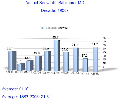
Snowfall Records- 1900s and 1910s

Since this is Christmas Eve I should note the most snow on Christmas Eve Day was 8.4" in 1966. When I get to the '60s in you will see a distinct jump in the snowfall. However, there is a small chance of some snow flurries for us Christmas Day. Here is the NAM 500mb map for Christmas Day. The vort maxes are highlighted with an X. These are areas of upper level support of clouds and showers - even when void of surface features. The colored area over MD is what separates us from High Pressure moving in. It is left over energy wrapped around the recent storm. If we have NW winds continue, then instability clouds will form to our west, and perhaps some flurries. Its not much, but it is something.

How often have you heard, "It snowed a lot more when I was a kid" or "My parents had to walk to school in 20 inches of snow. Uphill. Both Ways"?
This is the beginning of my look at snowfall in Baltimore, by season and decade. You will see the first two decades of the 1900s. While there are some outstanding years both high and low in snowfall, the average for each decade nearly matches the 124 year average: