Our last night in OBX and we had a good storm (apparently nothing like the storms B'more has had in the past week). We sat in a dark room- as the kids were trying to wind down late and my buddy Gene was just being Gene. It's nice to step away from the 'tube and just be a weather watcher in the crowd. Hopefully your browser can play these You Tube Clips. I'll be back in the StormCenter on Friday, for a very short week.
Wednesday, July 30, 2008
Lightning Reaction On Video
Cape Hatteras- Natural Erosion Changing the Coast
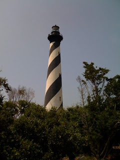
My trip to the lighthouse yesterday was interrupted by heat and an injury (some guy passed out and fell down inside the lighthouse). As a result, I have to make another trip back to this historic place.  It's a place I have studied, and followed with so many coastal storms (especially those developing winer Nor'Easters). Cape Hatteras is a cape on the coast of North Carolina. It is the point that protrudes the furthest to the southeast along the northeast-to-southwest line of the Atlantic coast of North America, making it a key point for navigation along the eastern seaboard. So many ships have been lost around it that the area is known as the “Graveyard of the Atlantic” . The nearby shoals are known as Diamond Shoals.
The cape is actually a bend in Hatteras Island, one of the long thin barrier islands that make up the Outer Banks. The first lighthouse at the cape was built in 1803; it was replaced by the current Cape Hatteras Lighthouse in 1870, which at 196 ft is the tallest brick lighthouse in the United States. Topped with an iron superstructure, it is 208 ft tall and coast $155,000 to build.
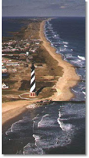
 In 1999, as the receding shoreline had came dangerously close to Cape Hatteras Lighthouse, the lighthouse was lifted and moved inland over a distance of 2900 feet. Its distance from the seashore is now 1500 feet, about the same as when it was originally built. Most of the 1400 ft of beach lost since the relocation of the lighthouse was due to Hurricane Isabel in 2003.
Oceanographically, it is of interest because it is a point of confluence for two opposing currents: the warm Gulf Stream moving north, and a cold Virginian current moving south. Somewhat analogous to Point Conception in Southern California, this on-the-edge placement leads to unusually diverse biological assemblages. Many species’ ranges have either a southern or northern terminus at the cape.
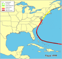
Cape Hatteras is also infamous for being frequently struck by hurricanes that move up the East Coast of the United States. In 1999 Floyd brought Maryland flooding, but it was OBX (the Outer Banks) that had direct landfall. The strike of Hurricane Isabel in 2003 was particularly devastating for the area. Isabel devastated the entire Outer Banks and also split the two small towns of Frisco and Hatteras in half. NC 12, which provides a direct route from Nags Head to Hatteras Island, was broken in half by the hurricane. This nearly demolished the small villages of Cape Hatteras. Students had to use a ferry to get to school for almost a year. Reconstruction of the area began in 2005. These two tracks show how NC sticks out and can get hit from many directions.
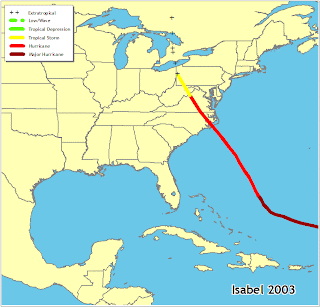 What I always found facsinating, was that the coastline from NC
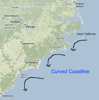 down through SC has a few circular patterns to it, carved out from geographically favored land falling zones of hurricanes. The natural ebb and flow around the counter-clockwise circulation have helped to distribute the sand and the land... See the map in greater detail if you can ...
Tuesday, July 29, 2008
Friday, July 25, 2008
Thanks a lot Christobol
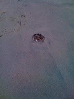
Atlantic, it created upwelling. Who would have thought late July
would have water temps in the upper 60's? That resulted in tons of
Jelly Fish like this to try and warm up on the shore. Too close and
this guy didn't make it. Still fact fimding and testing the iPhone.
It still works. :-)
Wednesday, July 23, 2008
Hello Dolly, Goodbye Justin- Sort of...
A category 1 storm in strengthening mode can be more destructive than a
Cat 2 making landfall while weakening. Dolly has tightened up this
morning and could reach Cat 2, but will hold together a bit inland
while slowing down forward movement.
LOCALLY
Flooding is likely as we break the heat wave. Our front has nothing
to do with Dolly, but will give us our own problems as it slows down.
I expect 1-3 inches of rain beginning mid day...
FACT FINDING MISSION:
I will be gone for some, uh, research for a few days. I will be
testing my new iPhone's capabilities on location with all it can do.
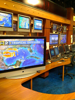
This blog was sent from my iphone along with this picture of the
StormCenter. I will post more along the way so let's see how it holds up. I'll be back in the station
next week.
Tuesday, July 22, 2008
Heat Wave winding Down, Dolly Gearing Up
 Are you tired of the heat? I am! In fact I was 6 days ago. Today would make day 7 of this heat wave (90F+ temps). A cluster of storms erupted overnight, and split into two parts. This is the surface map from 7am, and it highlights the front that is responsible for the storms. Today we should see the clouds arrive around lunch time, and stick around through Wednesday. With that in mind, our temperatures should take a drop. Wednesday's temperatures will be determines by how much rain we have. More rain will keep us in the lower 80s, but if it's just a morning and then an afternoon/event event split- we could be in the upper 80s and quite muggy. It will take until Thursday morning at the earliest to get this through.
Dolly soon to be a Hurricane:
The sea surface temperature map here shows the pool of water above 86F feeding into part of this storm. That is good fuel, in addition to a favorable upper level environment to strengthen.
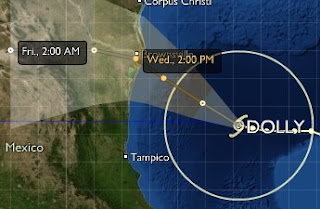
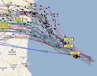
a really good website for tracking the tropics is Stormpulse. Click on the Dolly map below for a link. Below these images you can see a spaghetti plot of all of the forecast models on Dolly. No doubt it will make landfall tomorrow. The question is where. That covers a wide range. When a hurricane Watch it issued, it often covers 100 miles of coastline, but about 30 miles of that stretch see the worst result. The right or north side of this landfall will have the largest storm surge and flooding. The problem is that this will be a storm in strengthening mode. That means a Category 1 or 2 can do more damage than expected as it makes landfall with the potential energy this storm would have if it continued over water. In contrast, a weakening storm would tend to fall apart quickly, since it would already be trending downward in intensity.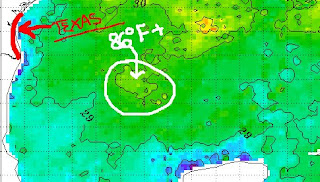
Monday, July 21, 2008
Hello Dolly!- Goodbye Bertha and Christobol
 I hate to play the game " I told you so...", but anyone who did watch my forecast Late Thursday and Friday morning heard me talk about the southeast coast. Well it looks like Christobol developed in a hurry and just enough to drop beneficial rain to North Carolina. Now it jumps off of the coast and we can focus on the heat, afternoon storms and the developing tropics. Our chance of rain will move in Tuesday with that complex in the mid-west this morning. We could have a dramatic drop in temperatures on Wednesday with clouds and rain around...
More Tropical Activity
It is like popcorn in the microwave. You sit, and wait, and then the slow popping becomes a constant chatter... Here is Tropical Storm Dolly- as of 5am.
If you go remember my discussion on Bertha- I mentioned the likelihood of a model track bias. Bertha ended up on the 'right' side of the forecast cone. Considering the weekend track for Christobol- the same story. Instead of hugging the coast, it is jumping out to the Atlantic. That is why I see the good potential of Dolly hitting Texas.
The current track has it very close to the boarder resort of South Padre Island, but I would lean north of that between Brownsville and Corpus Christi.
Here is the NAM model has it a little faster, but on the northern edge of the forecast cone.This is the model output for Wednesday morning. A day faster, but with the impact of a growing storm. As it enters the Gulf of Mexico, it will move over some very warm pools of water. Temperature range is from 86F to near 90F. Tomorrow I will pull up some of those water temperature maps and see if there is a better handle on the storm track.
Friday, July 18, 2008
Here We Go: More Heat and Humidity
 Yuk! I hate this stuff. I've said it before, but until I can unzip my skin, there I'd rather have the cold and pile on another layer.
It's high pressure that provides sinking air to limit the clouds, and the wind. Combine that with high July sun angle and temps in the middle 90s- and the pollution has not place to go. This Code red, essential means: Stay inside if you can. By reading this, you are likely in an air conditioned home or library. Stay! I don't se much change until maybe some storms roll in late night Saturday, but that will likely be to our north. So it's Sunday and beyond when the humidity will have a chance to burst some storms. It will take a few days to break though.... How about the Cecil County Fair? That begins today. I wrote about my NorthEast /ElkNeck visit already, but the people up there were so nice, it's worth another plug. You can find out more of the action here.
Kiss Your Asteroid Do you see it?
This graphic shows the new asteroid named 21619 Johnshopkins. It replaces the old name 1999 JN136 . Hope that clears it up. More can be found here, or by clicking the image at the left.
Thursday, July 17, 2008
What To Do in the Heat
 Yesterday I worked our new series- 1 Tank Trips. I spent the day in North East and Elk Neck State Park in Cecil County. We are shooting ahead of schedule, so the story will not air until August 8th. (If you see a similar story on WBAL- just know that stole it from me and read about it here first).
While I do not want to give too much away... WOW! 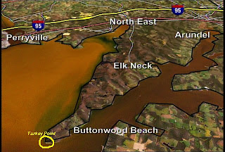 What a beautiful spot. It had been a few years since I was last there, but I can guarantee it will not be that long until I back. Located at the north end the Chesapeake Bay, it is surprisingly hilly. Turkey Point, located on the south end of the southern end of the park, is on a 100 foot bluff. There you will see the highest elevated Lighthouse in Maryland, surrounded by a vista on 3 sides with the Bay and the Susquehanna River. Below is the latest camera view from our weatherbug station at North Bay looking west. This is a great spot on hot summer days, since the typical warm wind from the south and southwest will cool a little bit passing over the water. The visibility will go down as the haze creeps in this weekend, but this is my pick for a local trip in this heat wave.
Urban Pirate Cruise:
Wednesday, July 16, 2008
Heat: Right On Schedule
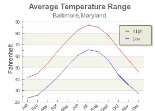
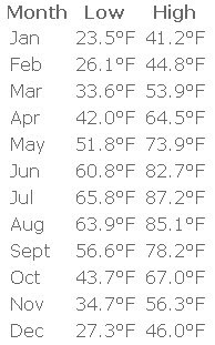
The middle of July is climatologically the hottest time of the year. Just look at the graph and you can see the average high temperatures are in July. It's called the seasonal temperature lag. Even though the sun has been dropping lower in the sky, and the days have been getting shorter in the past month, the ground and water are still warming up. The air temperature begins to drop in August, but the ocean water reaches it's peak in September- coinciding with the peak of Hurricane season.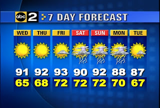 Here is my forecast (from Wednesday morning). I expect the next 5 days to be in the 90s... but this is not too oppressive.
Rip Currents: Bertha continues to move away, and the undertow will ease up, but it has been a deadly week on the East coast. Click this link for more information on Rip Current safety.
Tuesday, July 15, 2008
Earth: The Biography
 As we enter a quiet and rather boring hot weather pattern this week... I thought I would introduce you to a series on cable this week. Earth: The Biography on National Geographic Channel. I know some of you don't have this channel on your cable, but if you do, and in HD even better. Thanks to my DVR I was able to record it and watch the Home Run Derby last night. What I did see what well done. Everything from the video and animation, right down to the announcer with a British accent. The episode last night was about the atmosphere, but tonight is all about ice. Whether there is a Global Warming undertone- I have yet to find out..but if you see it, let me know what you think. Little video clips can be found on this link.
Monday, July 14, 2008
Front Crawls, We Get Healthy Rain
Rain For Some: Like I mentioned yesterday:
In part thanks to Bertha near Bermuda and the traffic jam off of the coast, our cold front put on the brakes last night. Here you can see the Rainfall Totals ending at 5am. They ranged from about 1.5 inches in Carrol and Howard Counties to nearly nothing on the Eastern Shore.
With the front on the move, you can, you can track todays rainfall in Rock Hall at Belcak's weather station. Very Cool!
East Coast Traffic Jam Here is the surface map and infrared satellite from this morning. There is High Pressure stuck between our front and TS Bertha. Regardless, it's all stuck. As Bertha begins to make the turn and move on it's way, we will get that front out of here. In the process, we hope for our clearing this afternoon. I have my own motive- a round of golf this afternoon. It's only my second round of the year, and my family at the beach, I need to get this in. I think it will work out, but that's here in Baltimore. Planning golf or a day at the pool on the Eastern Shore- uh, I don't think so. This front will be your headache in the afternoon.
We all get a break tomorrow, and a return of 90 degree heat for the second half of the week.
The tropics are looking a bit more active, with a few waves under scrutiny near the ITCZ. Below is the wide view. That Wave #1 has a high probability of becoming Cristobal.
Sunday, July 13, 2008
Bertha Rips Coast- From a Distance
 It's been nearly a week and a half, and Bertha has slowed to a crawl- on the other side of Bermuda. While it has turned to corner, and is expected to stay far out to sea, the waves have made their way to the east coast. Bertha had some help. Here you can see the clockwise wind around the Atlantic High Pressure, and eave the counter clockwise flow around a wave of Low Pressure that has formed along our old frontal boundary just off the coast. All has provided the push of waves and rip of the tide. Here you can read how the lifeguards on the Jersey shore had to stay alert all weekend.
 The added humidity and the approaching cold front from the Ohio Valley will spark some strong thunderstorms later today. The Storm Prediction Center has the slight risk of Severe Storms (large hail and damaging wind) for the mountains just to our west. I have two concerns here for us locally:
1st: The wind direction. Much like yesterday, I expect a south to southeast flow. That southeast wind direction adds humidity off of the bay, and upslope for the metro area north and west of the beltway. That can enhance any showers that develop in the mountains. So while you may sometimes watch storms in the mountains tear apart or skip north of us, this is a situation where we will have to watch whatever develops potential reach us by this evening.
2nd: There is a bit of traffic off the coast to our east. That will likely slow the front down. While the models have it passing through Monday morning, it may linger and keep the chance around for my round of golf in the afternoon. It's only my second round this year, so I have an agenda. I'd like to clear us out completely, but Monday afternoon showers may redevelop near the bay and the eastern shore...
Friday, July 11, 2008
Beachy Weekend
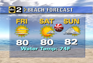 I am spent. It's been a busy one, and I slacked a little on the blog- but it is the the middle of summer. While we air for 90F this weekend, most of my family heads to the beach- sans me. At least the picked a prime time with this forecast.
If any storms pop up on Sunday, I'll check in. Otherwise, enjoy a low keyed weekend.
Thursday, July 10, 2008
Storm Gone, Humidity Dropping
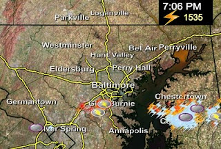 I was out in Chestertown yesterday working on a story for Good Morning Maryland (it will air July 25th). This storm that blew through brought them over 1 inch of rain and this lightning display. That was 1,535 lightning strikes in a 30 minute span. This was one of those storms that grew strong crossing the bay. Funny how the locals were just telling me that most of this summer has been the opposite.
I just found a local weather station that has peaked my interest and look forward to sharing more later. Unfortunately I am out the door for more- another one of the 1 tank trips.
Enjoy the improving weather. It will stick around through most of the weekend.
Wednesday, July 9, 2008
Environment/Energy: Pickens Plan
Unfortunately I have a buys schedule for today and have to jump out of the studio early for story shoot. Showers and storms likely today. You can always watch the latest radar, warnings, and temperature maps on my links (main web site) above. Try the Storm Page and TV Graphics.
Now about that energy issue. While my loyal viewers know that I do not agree with the exploited Global Warming hysteria... I do support and endorse alternative energy. I wish there was more government subsidies for solar panels and I was have them on my rood tomorrow. However oil tycoon T. Boone Pickens has been making the circuit promoting his plan for energy that he addressed to Bush Senior back in the early 90s. Since Clinton wasn't discussing it, Bush stayed away from the issue. Pickens predicted that 2008 would be the year we hit this crisis. Here is his video plan below:
Find out more on his web site Pickensplan.com
Tuesday, July 8, 2008
Hurricane Bertha: Not Big, but Strong
 Overnight, Bertha jumped to a Category 3 on the Saffir-Simpson Scale.
Here is the latest image with stats and forecast. As you can see, the trend continues to push it farther east. Bermuda may escape this threat with just high surf.
One thing to note: Will this trend continue all season? I have noticed in seasons past, that the models (such as the GFDL) that the NHC uses to dominate it's forecast track can have a bias farther east or left of it's track.
Locally: 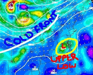 We will have more heat and more storms. There was a flare up of showers in Virginia early this morning. This is in response to this upper level Low. This will slowly slide to the coast today, and help to develop more storms this afternoon. In the meantime, we will have more sunshine- boosting us into the 90s. That heat and this upper level support can make some storms push severe limits. That means:
- Large Hail (3/4 inch)
- Strong Winds (over60mph)
- Heavy Downpours
Monday, July 7, 2008
Maryland Swamp! Berthan Now a Hurricane
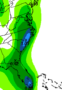 How about that rain? A burst of tropical rain moved through Baltimore and Harford Counties around 3 and 4 this morning. Some spots had over 1 inch of rain. Considering the rain over the weekend, and we are making up for the lack of wet weather in June.
Here is the projected rainfall for today. An average of 1/4 to 1/2 inch. However, local storms (like this morning) can easily dump over 1 inch.
This whole will take another two days to move off of the coast, and it will just be a waiting game. Watching the radar will determine when the showers pop up, and where they move. It's going to be some daytime heating that will provide the trigger.
HURRICANE BERTHA This is the update from 5am. I've got more images on my old tropics page. Click the image for more. The track shows a typical curve before reaching the US coastline. This is in part due to our coastal front that will be on the move and help steer this storm. Bermuda may be under the gun, but there is a wide range of error at day 5. It will be interesting to compare the actual track to this forecast on Friday.
Friday, July 4, 2008
Holiday Weekend Basics and Tropical Storm Bertha
First: Here is the first installment of my series (I will post as soon as it's ready)- Tank of Gas Getaway. I was a t Havre de Grace, and want to thank Mayor Dougherty, Bridget Layton- head of City Tourism, and Captain Glenn who took me up on the Parasail.
Since it is a holiday, I will be taking a little break from blogging. I have posted some graphics that will update. It looks like it will be wet, so you will have somethings to look at. A reminder that you can find more on my full web site. check the Storm Page and TV Graphics....
Enhanced Radar
Lightning Tracker...
Bertha was named a Tropical Storm on July 3rd... it was just off of the African Coast and heading into the open Atlantic.
Thursday, July 3, 2008
Mini Heat Wave, Holiday Humidity, Beach Bummer
 Today is the first and last day of this heat wave. So basically, it isn't. I expect us to get up to the low 90s, but it will take some effort. This approaching front has thrown some clouds our way this morning- but it made for this great 'pink sky' as viewed from the Maryland Science Center- across the Inner Harbor to the National Aquarium.
While this band of high, thin clouds did make it closer than I thought, I still expect a mostly sunny day. Here is the morning surface map. That High Pressure sliding off the coast will allow a shift of wind to the southwest. The approaching cold front will help the pressure gradient pump up the wind. This afternoon gusts up to 20mph will get our temps into the 90s.
I've also analyzed a developing wave along the front in Missouri. In fact there are a few of these- and that will help to slow down the front this weekend. Typically cold fronts are fast movers, but this time of year, they don't have the cold air push behind them to through the Mid Atlantic. The tough thing is the timing of the first round of rain. Depending on how close it can get tomorrow, we also have to consider the wind shift to the south and south east. That is a more humid flow, and often increases our chance of pre-frontal rain. Right now, I am leaning towards July 4th to turn mostly cloudy and humid. We will just have to watch the radar for rain and storms to develop- but I would bring the storm chance to 40% downtown in the evening. It is likely to transition to a stationary front and stick around for the weekend. This will cause our winds to stay southeast and hold the clouds in place. Watching the wave along the front- Sunday appears to be the best chance for more widespread rain, and cooler temperatures.
Sorry, but this outlook seems to be spiralling down each day.
Wednesday, July 2, 2008
Great Today- Outlook for July4th Not So Good!
 Often the big blue H on the weather map translates to blue sky. "Blue High, Blue Sky", is what I used to tell my students.
Well this one has warmed up the mid levels of the atmosphere, so we will likely hold off the development of the abundant clouds the last few days brought us during the afternoons. This will be a quick mover, so the shift to a warmer southerly wind will be here Thursday. That means a return back into the 90s, and a little more humidity. Par for the the July course.  However, things start slowing down over the weekend. That High will find a happy home off of the coast, near Bermuda. That is a common summer event. One that in many summers would bring us those famous heat waves. This ridge of HIGH Pressure is not large enough and will move too far to the east before it settles in place. That will all the next cold front to slow down and possible stall overhead. The timing is all wrong- on the holiday weekend.
I want to see how the models handle this today and tomorrow. But now it does look like our rain chances go up especially Sunday.
Tuesday, July 1, 2008
Halfway Through The Year
July 1st marks the beginning of the second half of the calendar year. So far here is how we stack so far:
Snowfall: -9.7 inches (below normal)
Rainfall: +2.99 inches (above normal)
Temperature: Note Degree days are based on the daily average of 65F. This is the basis for planting crops and energy management. If the average of the High and Low temperature for a day is 45F, that would be 20 cooling degree days. If the average for a day is 75F, that would be 10 heating degree days.
Heating Degree Days Used in cooler seasons. Daily average below 65F
-396 (less than normal- or slight warmer)
Cooling Degree Days- Used in warmer seasons. Daily average above 65F
+34 (slightly more than normal- or cooler).
Our weather pattern shows that a mild winter has not translated into the spring and summer. While we still have a most of the summer to go, we have had a trend of near or below normal temperatures. We can thank the second wettest May on record for that.
Coolest Day of the Week:

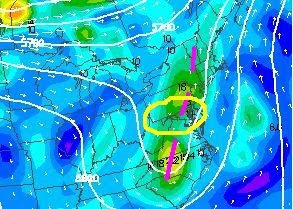
This upper level low will spin overhead today, and lift out tomorrow. But while it is here- it will provide enough instability to make it feel almost like autumn. A clear morning will quickly turn cloudy as ground warming and cool air aloft interact. More showers and storms likely this afternoon as well.
We will warm in a hurry tomorrow back into the mid and upper 80s. Outlook for the 4th could be wet. More on that tomorrow.

