Since this is Christmas Eve I should note the most snow on Christmas Eve Day was 8.4" in 1966. When I get to the '60s in you will see a distinct jump in the snowfall.  However, there is a small chance of some snow flurries for us Christmas Day. Here is the NAM 500mb map for Christmas Day. The vort maxes are highlighted with an X. These are areas of upper level support of clouds and showers - even when void of surface features. The colored area over MD is what separates us from High Pressure moving in. It is left over energy wrapped around the recent storm. If we have NW winds continue, then instability clouds will form to our west, and perhaps some flurries. Its not much, but it is something.
How often have you heard, "It snowed a lot more when I was a kid" or "My parents had to walk to school in 20 inches of snow. Uphill. Both Ways"?
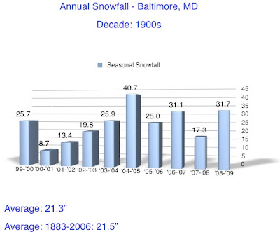
This is the beginning of my look at snowfall in Baltimore, by season and decade. You will see the first two decades of the 1900s. While there are some outstanding years both high and low in snowfall, the average for each decade nearly matches the 124 year average:

Monday, December 24, 2007
Snowfall Records- 1900s and 1910s
Labels:
holiday,
snowfall records
Subscribe to:
Post Comments (Atom)


No comments:
Post a Comment