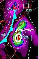
Here is the GFS model for Saturday morning. It has the center of Hanna just a little closer to the coast, but still very close. Do you remember my right side bias with tropical systems? I have been able to point it out with most storms whit season, except Gustav. Many of these tropical systems have ended up traveling on the right side of that forecast cone. Well, below are the latest tracks for Hanna. You can see a shift to the right side of the track- or to the east. Not much, but still worth noting. While I have pumped up the path crossing Baltimore for the past 2 days, I would have been surprised if that worked out just like that, but I still expect wind and rain Friday night into Saturday. We have to consider a few things:
1. Hanna is just starting to turn this morning. When it does, and the exact angle of acceleration will help determine landfall and beyon d.
d.
2. Wind Sheer is relaxing. Hanna has taken a major hit with upper level winds recently, but that relaxes today and allows it to regenerate over warm water.
3. North Atlantic Storm. This Low east of New England actually produced a band of rain in MA that dove south through Long Island. It is producing a band of clouds just to our east this morning. This does need to get out of the way, but could take it's time and deflect Hanna
4. Cold Front from the Great Lakes should help accelerate Hanna and push it out of here in a hurry. These fronts often get here later than expected, and will also determine how Hanna gets turned and spun through the Mid Atlantic. The longer Hanna takes to get here, the closer that front gets, and a better chance to keep Hanna farther east. However, the interaction with the cold front will produce another band of heavy rain and severe storms away from the storm center.
While the Atlantic is now filled with 3 Tropical Storms, let's focus on Hanna maps below. You'll Notice that the National Hurricane Center keeps Hanna as a Tropical Storm when passing us on Saturday.
Wednesday, September 3, 2008
Hanna Hype, Track To The Right
Subscribe to:
Post Comments (Atom)


1 comment:
So I am wondering if Hanna could end up doing what Isabel did coming up threw the bay and gathering more strength?? If i remember correctly. Is it possible? and will hanna be the same strength when it hits? please post a blog answering if you get the time
Alexis
Post a Comment