A no name storm yesterday leads to recently named storm this weekend. More about my paraphrasing lyrics and soon to be 'Hurricane' Kyle below... I do want to start with this satellite image of our no name Non Tropical- Tropical Storm. The convection, or developing storms around the center of circulation appeared to develop an eye off shore. This storm was responsible for coastal flooding and wave heights over 15 feet. My newly beloved Outer Banks of North Carolina took a hit on Nags Head with flooding on Virginia Dare Trail and Croatan Highway. But just like many tropical systems interacting the east coast, the rain and wind spread out on the north side. That is due to the onshore flow. But was some dry air wraps in off of the land, I highlighted a dry slot in yellow. that has caused the heavy rain band to split to the north s the center of circulation continued to push westward into the North/South Carolina border.
This dry slot can bust a rain forecast for some while others verify. Yesterday's rain ranged from Baltimore: 0.28"
Eastern Shore's American Corner 1.63"
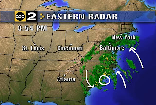
Ocean City: 2.00" (Doppler Radar Estimated) The radar image from Thursday evening posted here shows the onshore flow and the broken bands of rain. That distinct eye like circulation made landfall between Myrle Beach, SC and Wilmington, NC. The afternoon will generate more rain, but it's a matter of watching where they develop to determine where it goes.
While heavy rain hit the Eastern Shore and beaches that resulted in 1- 3 inches yesterday, the banding has split the rain into pieces. The models I posted yesterday, and the updates since still show the heaviest rain near the center of the storm to our south, and the tropical feed off of the Atlantic into metro New York to our north.
As I mentioned yesterday, the combination of this storm and strong High Pressure east of Maine have funneled steady and sturdy winds well north of the storm. Here are the strongest winds from Thursday's reported on our Storm Center Weathernet:
Delaware:
Fenwick: 52 mph
Lewes, The University of DE : 50 mph
Rehoboth, Beach Plaza Hotel: 57 mph
Maryland:
Ocean City Chamber of Commerce: 56 mph
"After nine days I let the horse run free
cause the desert had turned to sea
There were plants and birds and rocks and things
There was sand and hills and rings"
OK the classic song from America is a stretch, but I could not get it out of my head. Instead of nine days, it's nine months into the year to bring some relief to the drought in the southeast mountains and coastal North Carolina. Here is the active link to the Eastern Satellite and Radar for you to compare what areas in need are getting hit with rain.
The second storm I mentioned is yesterday, that will hit New England is now Tropical Storm Kyle. This circulation around our storm will steer this quickly north. It should stay well offshore, but reach Hurricane status before clipping Cape Cod. Here is the National Hurricane Center forecast.
I have to leave it at this point. I have a busy slate today, but I will try to post more on the rest of this storm and our weekend later today.
Friday, September 26, 2008
Rolling In Off The Ocean on a Storm With No Name
Labels:
coastal storm,
drought,
windy
Subscribe to:
Post Comments (Atom)


No comments:
Post a Comment