 As I mentioned on Examiner.com this morning, the models and my resulting forecast changed a bit after the morning package came in yesterday. On that note, I am going to wait until I get the new data to make my post here today. Please check back. In the meantime, the HPC rainfall forecast has gone up from yesterday. I had said that a shift in speed or track may double our totals... well we are getting close to it.
I have kept the regional radar at the bottom of this post, but you can get it on my TV Graphics tab above.
Below is my model analysis, but some of the maps are not easy to read. I have cut out our region, along with highlighting Maryland in a yellow circle.
Late Morning UPDATE:
 Now that the models are trickling in, I can see the development, or perhaps over excitement of cold air in the computer models. There is a ton of information to sort through, but what I try to do here is provide the best graphical display. I will try to keep this short, but sweet.
The NGM (here), shows the next development for Saturday morning. This looked heavier on the NAM model, but the rain that moves on late Friday, will be here on Saturday morning, but perhaps break into showers during the day. The arctic boundary to our west will turn rain to snow in Chicago. That white line shows the freezing line. Could be interesting football weather in Michigan mid day.
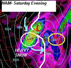
The NAM shows low pressure slowly passing overhead, and keeping steady rain around through Saturday evening. The low in the Great Lakes looks stronger here, and the band of precipitation behind the freezing line would translate to heavy snow from Chicago to South Bend, IN, and Michigan. The way this wraps up, will pull cold air farther south behind the storm. That will arrive on Sunday- and settle in on Monday.
Snow Next Week?

 Here is my personal favorite- the Canadian (from Environmental Canada) showing the surface and upper level maps behind this storm on Monday. On the left, the surface map shows what is left of the Low Pressure Center, just spinning itself out. It is stacked aloft, and circulating cold air around it, while drifting east of the Great Lakes. The black line is the 'freezing' line that is well to our south and moving off of the coast. It does not guarantee freezing temperatures for us, but it supports snow development in the clouds. The image on the right, shows the upper level chart at 500mb. This is the energy needed to generate showers, and there is a lot of it. The push of arctic air moves in during the day, keeping us in the 40s, with an afternoon rain or snow shower. The X in Ohio is the second push with the core of the cold air. That will arrive on Tuesday. This is why I put rain or snow showers for Monday, but snow showers or flurries on Tuesday. Usually the best chance for this is in the hilly terrain north and west of Baltimore, I will fine tune this we get closer. Just showers- but a start and sign of the changing season.


No comments:
Post a Comment