"Go-cart Mozart, was checking out the weather chart To see if it was safe outside.."
That's a Manfred Mann tune, which often gets misquoted, but seemed to fit here:
"Blinded by the light, revved up light a deuce, another runner in the night."
Deuce= car
There has been a tremendous amount of buzz about a storm at the end of this week. For time sake I refer you to Mr. Foot's blog who did an extensive analysis of the La Nina, North Atlantic Oscillation, etc.. this past weekend. He may be a little more optimistic than me at this time. The excitement by many may be compounded by a lackluster Maryland winter, and the 5 year anniversary of our #1 snow- record Presidents Week storm in 2003. There are a tremendous amount of pictures and information on the internet of this storm, and I wanted to focus on something different today. Click here for the Feb 17, 2003 radar. Here is a general storm breakdown and comparison.
Anniversary of more big storms:
Among the top 11 snowstorms in Baltimore- 6 have occurred in mid February:
#1: Feb 16-17 2003 28.3"
#3: Feb 11-12 1983 22.8"
#6: Feb 11-14 1899 21.4"
#7: Feb 18-19 1979 20.0"
#8: Feb 15-16 1958 15.5"
#11: Feb 11-12 2006 13.1" (Many have forgotten about this recent storm)
For the regular readers of my blog, you know two main things about me: First- I LOVE SNOW! Second, and most important- I don't like to push the panic button too soon. I have learned a lot in my nearly 2 decade career. Bias can burn you! As good (for those of us that want snow) as something may look 5 days out, things can change. Models change, and all of the ingredients that go into forming a storm may not line up as needed. The more you want snow, you may be blinded by the real data or few models that indicate otherwise. That is my hesitation for Thursday -Saturday's event.
First: the step down in temps will provide a few shots of snow. If you have seen my 7 Day forecast (click the TV Graphics tab above), it looks much more impressive than what will play out.
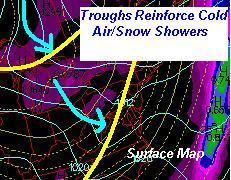
Two surface trough shows a step down in temperatures. They may not show up a true cold fronts on the weather map, but these kinks in the isobars will in mark a wind shift and temperature drop.
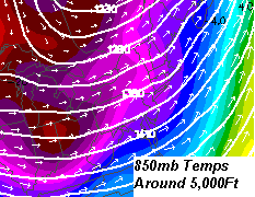
The 850mb temps(cooling at 5,000Ft) show a drop back to -10C and colder.
The 500mb vorticity max= a spin in the upper levels to help enhance the chance of showers as the cold air builds back in...

Friday Morning:
- How cold will it get here. This will show the strength of the new air mass. If we stay in the 30s (BWI) on Wednesday- that is colder than my forecast and a sign it might stay colder.
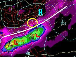
- Where will the High will be positioned? I see it very close to MD on Thursday. If the center can stay north, or slides past sooner, thigh might allow this storm to slip up the back side and bring in more moisture.
- When will the High pass? When will the southern branch develop it's Lows? Timing is crucial with this southern branch. If it acts up sooner than Thursday- then it could all pass well to our south. If it develops later than Friday morning, then #1 and #2 will have to be asked differently.
"Faith in the flakes."


3 comments:
Justin, thanks for your headline and mention of the site. Wasn't seeking additional visibility, but that's quite all right.
I'm right with you on the dangers of jumping too soon. The driving forces behind my thinking is:
1. We've (as in many of us weather watchers) underestimated the strength and duration of cold air once it arrived in our area.
2. Given the potential size and placement of that high come Thu-Fri, I'm very concerned about the possible setup of an easterly fetch pulling moisture off an above normal Gulf stream.
3. Since the high currently projected to press in fairly strong, I'm wondering about the "squeeze out" effect (my own term) where the moisture building up in the SE has to go somewhere and can't really just head due east especially if the High extends out into the North Atlantic. That could temporarily create a mini blocking situation. Then you get overrunning by default.
Of course, as always.. a lot could change and I will make that more clear in a little revision in your honor.
When you look at the overall pattern and HOW things have been evolving this year ... I just CAN'T get hyped on this one. I WANT to get hyped but as you mentioned ... can't start honking yet. The 850MB on the 12Z GFS is ugly.
Cautious Optimism.
I'd rather change my attitude late for the better than pull back...
Plan for the worst and hope for the best. The overall jet has been very active- just one taste is all we need.
Post a Comment